 Cargando...
 Cargando...
In this tour guide you will discover information about tourism in the Canaries and on each island, which lie from the north cost of Africa, bathed by the Atlantic Ocean.
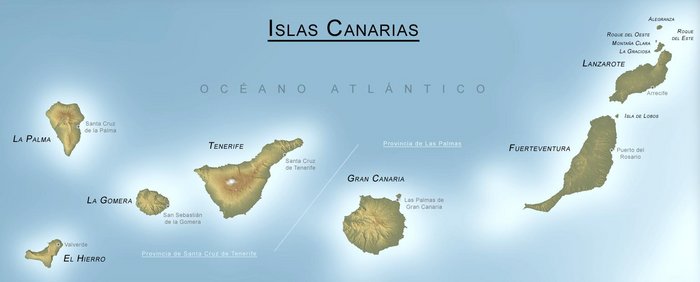
Canaries are constituted by seven larger islands: Tenerife, Fuerteventura, Gran Canaria, Lanzarote, La Palma, La Gomera and El Hierro; and several other smaller islands, among which stand out: La Graciosa, Alegranza and Lobos.
The coast of the islands is in it’s majority lined with long sandy beaches and are punctuated by reefs, coves, and deep bays. In some areas, however, cliffs and more precipitous terrain predominate as you might perceive on the coast of Gran Canaria, or in north of Tenerife. The most common peculiarity of all Canary Islands is their volcanic topography.
Three regions can be distinguished from the topography of the islands: the central islands, the eastern islands, and the western islands. The volcanism has promoted highly unique landscape, with varied topographical forms (craters, cones, malpaises [badlands], tubes, etc.). The most representative geographical feature of the Canaries is El Teide, Spain´s highest peak, with an altitude of 3.718 meters. Due to the morphology of the islands and the lack of precipitation there are no water channels.
Map of the Canary Islands

Compare flight offers and book in advance to save some money.
Book now your Hotel or Apartment:
Find the largest offer in car rental for your holidays: